Water for Life
Water for life is a biological given; a construction that is both inalienable and immutable on our green-blue planet. From a cultural perspective, water is foundational for our societal institutions; the rules and norms that direct and influence its access and allocation, strongly affect all other raw and refined resources. Its scarcity or abundance to a region significantly dictates the kinds of social organizational adaptations we have made as a species. Our health and longevity depend on its availability; how it is delivered, who accesses it, and its quality and quantity identify levels of wellbeing. Ironically, those of us who are able to distance ourselves from a significant personal investment in water’s immediate and fundamental access–because of highly developed technologies and infrastructures–are frequently the least aware of its quotidian impact. Like the air we breathe, we can assume that water is an inexhaustible resource needing little more attention than our immediate preoccupation with our own bodies.
See the new book Irrigation in Early States: New Directions, edited by Stephanie Rost from The Oriental Institute of the University of Chicago
However, water is an exhaustible resource with finite ends. Our scholarly assessments of both the past and the present demonstrate the lengths to which our ancestors have gone in establishing and maintaining water access in sustaining their societal identities and before degrading their environments. There is no doubt that we live in world today of highly “progressive” interests—institutional arrangements—that promote economic growth dependent on technological advantage and advancing numbers of consumers. Past societies did not occupy as much geography or as intensively exploit it, a condition that frequently assumes that history cannot really affect our projections of our future; we are just so very different now than then. Nevertheless, there exist several bench mark societies that provide insights into a societal future of either more or less of it.
Because water is the most precious of all controllable resources–its more basic than food, and next in line after air in life requirements—a review of its past and present role for a “sustainable society” merits discussion. By introducing aspects of water’s influence and its implications for potentially less invasive approaches in its redeployment, we can address facets of our complex and frequently “wicked” institutional problem sets.
From the origins of agriculture to the beginnings of the archaic state, semiarid and semitropical environmental settings have been the seats for major social transitions in human history. Temperate settings that are identified with several of today’s most developed nation states generally are not the loci for the catalytic environmental and social conditions that precipitated the earliest experiments in social complexity—rather, this takes place in other ‘‘marginal,’’ very dry or very wet settings. Early and ‘‘first’’ experiments in urban social complexity are well documented in the Near East, with the initial appearance of the city by about 5000 years ago. In these semiarid settings, early city states tended toward nucleated settlement adaptations—tells–sophisticated canalization efforts among lower density hinterlands populations, and complex colonization attempts to harvest/exploit an otherwise parched terrain. Early investments in “technological breakthroughs” are associated with these settings, perhaps precipitated by a scarcity of organic resources away from the principal river arterials.
Semitropical settings demanded another socioenvironmental trajectory perhaps best identified by the ancient Maya of lowland Central America or the rich architectural and artifactual history of the ancient Khmer of present-day Cambodia. The diverse, yet dispersed, animal and plant resources available as well as a less predictable rainfall regime–seasonally timed, but frequently associated with too much or not enough water–together resulted in a landscape blanketed by a patchwork of communities that often developed specialized activities and subsistence strategies in the context of a socially cooperative exchange. This complex web of interacting and intersecting groups pulsated in varied and numerous directions through which information, knowledge, and goals were transmitted, connected or achieved. By cooperating and organizing in this manner, some groups appear to have made day-to-day decisions at the local level that had broad ramifications through time. As these cases will demonstrate, we see the emergence of a sustainable and resilient, low-density urbanism frequently associated with less overt hierarchy; cooperation without deeply entrenched competition or conflict. The developing social structures incorporate complex networks of human engagement, but often without truly complex or obsessive commitments to technology per se.
Human niche construction and water systems: connecting the short and long term
Animals, plants, and humans modify their environment by creating niches. In turn, these niches co-shape species evolutionary history. Niche construction theory helps us to understand how a multitude of small scale environmental adaptations can result in a complex system of social and environmental conditions with highly influential outcomes. All constructed niches are closely tied to water and its distribution; water is an absolute foundation of life.
A first application of human niche construction theory can be found in Wilkinson, Rayne & Jotheri (2015). The authors investigate a rather peculiar hydraulic landscape in ancient lower Mesopotamia, where irrigation consisted of very small tracts of fields that form a herringbone pattern on the land in aerial view. Another example comes from a study carried out by Zhu, Ertsen & Van de Giesen (2015) focusing on the ancient Hohokam, who occupied present-day Arizona, USA and drew on the perennial Gila River. This hot and dry area was settled by the Hohokam for at least 1500 years and was heavily dependent on irrigation to feed agricultural crops of mostly maize, beans and squash.
Among the case studies, urban-like centers or simply sizable population aggregates co-evolved with their sub-communities—or water districts—in integrating their different resource spheres and providing scheduled forums for interaction, material exchange and the promotion of inter-community relationships. Non-hierarchical complexity is attained; that is, heterarchy or a complex system of (near) equal networks that integrate the low-density agrarian urban-like landscape and resists the emergence of hierarchical systems that interfere with local adaptations.
One assumption laid to rest in these cases is a ‘‘tragedy of commons’’ assessment for the semitropical wetlands resource—inclusive of intensive rice cultivation. The notion that a collective good—like water—will be compromised by way of its diversion or consumption by one group in excess of its benefit to others is the essence of this socioeconomic tragedy; a logic based on self-interest and diminishing returns associate with poorly conserved supplies.
Amazonia
Recent breakthroughs in archaeology show that between 500 BC and AD 500 sedentism was well-stablished in Amazonia and significant populations were residing on plateau edges overlooking highly productive but seasonally inundated floodplains. By at least AD 1000, sizable populations of townspeople invested in mound building activities producing a highly domesticated landscape in a setting today considered less habitable by Western standards. Archaeology now reveals a noticeably different set of past landscapes and adaptations principally focused on expanding the ‘‘marginal’’ wetlands. Today’s fire-prone savannahs covering extensive reaches of the Amazon and providing only limited biodiversity were ditched and flooded in the past. Hundreds of kilometers of raised fields were built and hundreds to thousands of kilometers of headwater terraces were established by the first century AD.
The utility of this raised-field wetland system came in several forms. First, elevated fields in wetland settings can absorb at least a quarter-million cubic meters of water during seasonal deluges and associated runoff, with a slow release during the dry season. Second, squash, manioc, and sweet potato thrive on these raised-field surfaces as opposed to the abuses wreaked by slash-and-burn agriculture currently practiced. The two root crops noted characterize a ‘‘natural food storage’’ when left in the ground even beyond their annual seasonality, a major advantage in hot and humid surroundings that accelerate decomposition upon harvesting.
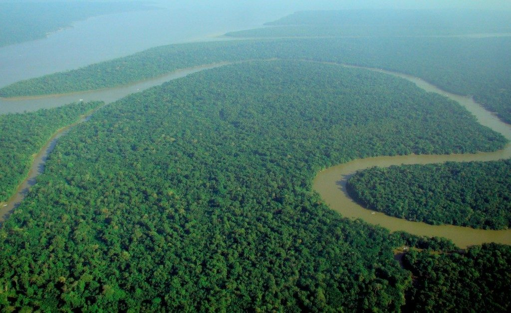
Although the highly patterned raised-field layout might appear carefully orchestrated by an overarching and commanding political body, this is not the case. They do not demand considerable upfront planning drawing from controlled access implementation of elaborate technologies, but rather the coordinated efforts of village-level and cooperative community labor and information exchange. Highly decentralized and governed by heterarchical relationships, these expanding and sustainable water and land-use systems challenge the notion of a ‘‘Tragedy of the Commons’’ so prevalent in discussions of capitalistic land-use models.
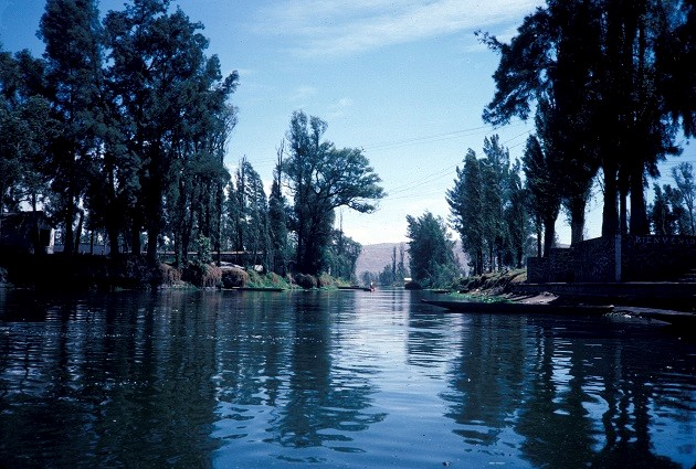
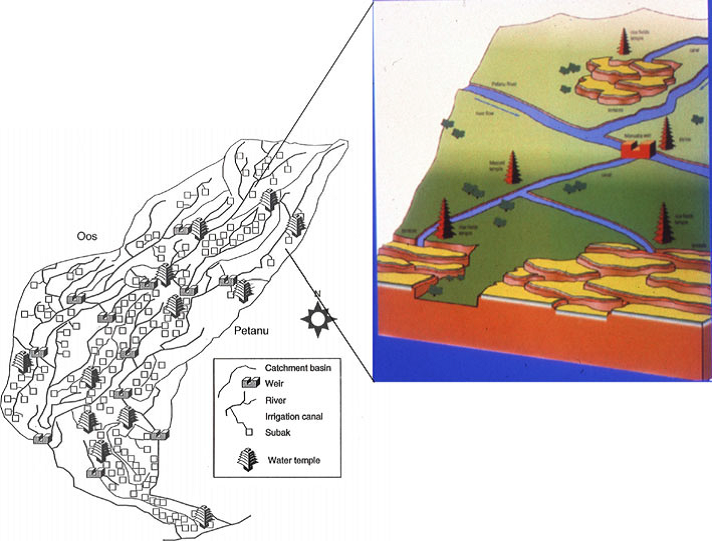
Bali
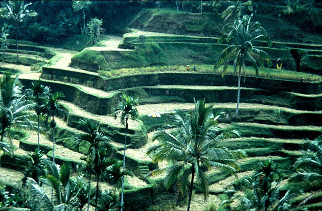
The most complex of wetland reclamations are the rice paddy systems of Southeast Asia. These highly engineered surfaces frequently hanging from dizzying stair-stepped slopes on the volcanic island of Bali capture in microcosm several zones of this greater region. The Indonesian island chain experiences a profound seasonality of precipitation resulting in significant socioeconomic organizational patterning. The Balinese rice paddy and subak land- and water-use system appears well-established by AD 1100 and continues to reflect the highly intensified wetland reclamation and extended use of these carefully controlled landscapes.
In the Balinese case, society is organized in a heterarchical manner as outlined in the Amazonian example. The agricultural base was organized around a series of water temples established and maintained by the crosscutting corporate unit of the subak or rice cooperative. Having self-organized by way of both the landscape changes within the narrow and highly incised valleys and the evolving interplay between the local farmers and their socioeconomic, sociopolitical and ideological institutions, the Balinese represent another way of assessing complexity.
Balinese are organized into ‘‘districts’’ determined in part by the diminutive, steep-sided drainages and valleys dissecting the island. These water districts tend to operate relatively independently of one another, but are highly interdependent within a district with the coordination of production, distribution, maintenance, and aspects of consumption assumed by the water temple loci. Ritualized and routinized labor tasking allows the continued promotion of incremental adjustments to the sustained success of the ever changing human-nature co-evolution.
Angkor Wat
The monumental city of Angkor (AD 800–1200) represents one of the largest preindustrial cities known, with a dispersed population extending over 1000 km2. Population estimates are difficult, but they appear to approach 750,000 within the expansive Khmer Empire of several million people. The districts of Angkor, apparent in a standard temple complex design of several hundred shrines, are surrounded by open fields and resemble the appearance of Balinese water temples; though they likely have a residential function, indicating that the shared community-level interdependencies noted for these early complex societies are repeated across the landscape. Angkor Thom, a palace and temple complex within the city of Angkor, serves as an example of these locally organized features. Its 3-km-long walls on each of its four sides encompass 900 hectares and over 90 km of roads, canals, and waterways. Within its walls are over 2600 artificial ponds for domestic use in accommodating its approximately 40,000 inhabitants.

In addition to the extensive road system frequently elevated and acting as a shunting system in diverting runoff and related drainage are the truly huge tanks or rectilinear reservoirs called baray. On the east and west flanks of the urban core are two baray measuring approximately 2 km wide by 8 km in length. It is likely that the monoculture of rice and its unique water and labor demands permitted such population concentrations; a condition that seems contrary to other semitropical cases discussed herein. The people of Angkor are likely to have adopted these monoculture technologies (and other technologies of subsistence) from the nearby Chinese and societies further west.
The urban core is surrounded by waterworks built by the Khmer between the ninth and thirteenth centuries that completely transformed the landscape. Like Bali today, it is difficult to distinguish what is ‘‘natural’’ from what is not. The hundreds of kilometers of canals were fed from several rivers, many of which filtered through or immediately around the baray.
It is important to note that Angkor invested significantly in the implementation of technologies inclusive of wheeled vehicles, metal tools—both bronze and iron—and the sail. Under these historical conditions empire was not only possible, it was realized. Nevertheless, several of the social underpinnings affecting any semitropical society remained (i.e., small community based). A worldview dependent on elaborately ritualized costly signaling (conspicuous material symbols, especially architecture) continued to coordinate and unite the dispersed community ‘‘districts’’ and cultivated the interdependencies of an embedded heterarchy.
The Maya Lowlands
The Maya Lowlands cover an area of 250,000 km2, comparable to the entirety of the United Kingdom, with the ancient Maya reflecting longevity of well over 1500 years and conservatively spanning a time from 600 BC to AD 900 without metal tools, the wheel, or beasts of burden. Although several periods were more turbulent than others with the rise and fall of urban-like states, a sophisticated and shared set of socioeconomic and sociopolitical tenets tethered to a deeply embedded worldview underpinned this evolving cultural and regional trajectory of social complexity.
The landscape remains characterized by an extremely limited water supply as a consequence of poor lateral surface drainage and the near immediate loss of the volumes of water that percolate into the porous and jointed limestone bedrock—not extractable given the stone-age technologies then available. Even though rainfall was abundant during more than half the year, the extended seasonal dry season resulted in significant water access deficits.
The Maya built their communities in immediate proximity to naturally ponded and low-lying seasonal water sources; and by quarrying and unearthing tanks and short canal segments, they produced a year-round, water-accessible built environment with the excavated fill used to construct their acropolises and pyramids. With time and population growth however, forest clearance associated with some form of short-fallow intensive slash-and-burn resulted in significant slope erosion. At this Late Preclassic to Early Classic (AD 200–550) period transition, the first clear evidence for landscape terracing occurs, an obvious reaction to soil loss.
During the Early and Late Classic periods (AD 300–800), the Maya engineered the landscape to divert rainfall and its tremendous quantities of runoff to fill tanks and reservoirs at the summits of ridges and hillocks. During the wet season, rainfall filled these elevated depressions with water nearly everywhere. As a result of their elevation, however, gravity release of their waters during the driest portions of the year subsequently supplied much of the core area of a community. The potable source was used to recharge smaller low-lying basins as well as to permit immediate consumption; and once a flow passed through a community, it was still harvestable as gray water for agricultural purposes.
Little evidence supports widespread and intensively canalized agricultural systems for the ancient Maya. Local ecological conditions, population densities, and water availability impacted the kinds of agricultural strategies used. Maya farmers emphasized diverse strategies depending on local settings, an adaptation conducive to cooperative strategies revolving around wetland cultivation, orchards, house gardens, swiddens, terracing, and forest management.
West Africa
Although located at latitude comparable to both the Angkor Empire and the Maya Lowlands, the Middle Niger drainage basins of present-day Mali abut the southern reaches of the Sahara Desert—a semiarid setting unlike the other examples treated, with 350–450 mm of annual rainfall.
Communities were dispersed along the river’s extensive margins due to the presence and concentration of levees for wet season cattle pasturage, rice soils, and basins for dry season fodder foraging, each of which were unevenly distributed. Well-understood population density assessments are unavailable, but the vagaries of the riverine life-support system determined the character of these heterarchically organized communities from 400 BC to AD 1000—a span comparable to that of the ancient Maya prior to their great political fragmentation or collapse. The largest of these settlements, Jenne-jeno, was located in an area with a relatively substantial amount of fertile soils and year-round pasture land.
Although no conclusive evidence for any large-scale ‘‘instillations’’ for water management exist that would predict concentrated state power, the role of smaller-scale water diversion features cannot be overlooked. But as mentioned in the Amazonian case, such investments likely changed the environmental parameters for the social system to an extent that communities evolved in novel and complex ways.
References and key publications:
Gwinn, V. R. 1990. The Chacoan Prehistory of the San Juan Basin. Academic Press, New York.
Lentz, D., Dunning, N. & Scarborough V. L. (editors). 2015 Tikal: Paleoecology of an Ancient Maya City.Cambridge University Press, New York.
Lentz, David L., Nicholas P. Dunning, Vernon L. Scarborough, Kevin S. Magee, Kim M. Thompson, Eric Weaver, Christopher Carr, Richard E. Terry, Gerald Islebe, Kenneth B. Tankersley, Liwy Grazioso Sierra, John G. Jones, Palma Buttles, Fred Valdez, and Carmen E. Ramos Hernandez. 2014. “Forests, Fields, and the Edge of Sustainability at the Ancient Maya City of Tikal.” Proceeding of the National Academy of Science. www.pnas.org/cgi/doi/10.1073/pnas.1408631111
Scarborough, V. L. & Lucero, L. 2011. “The Non-Hierarchical Development of Complexity in the Semitropics: Water and Cooperation”. Water History 2(2):185-205.
Scarborough, V. L. & Valdez, F. 2009. “An Alternative Order: The Dualistic Economies of the Ancient Maya.” Latin American Antiquity 20(1):207-27.
Scarborough, V. L . 2003b. “How to Interpret an Ancient Landscape. “ Proceedings of the National Academy of Sciences 100:4366-4368.
Scarborough, V. L. & Burnside W. R. 2010. Complexity and Sustainability: Perspectives from the Ancient Maya and the Modern Balinese. American Antiquity 75(2):327-63.
Scarborough, V. L. 2003a. “The Flow of Power: Ancient Water Systems and Landscapes.” School of American Research Press, Santa Fe.
Scarborough, V. L. 2005. “Landscapes of Power.” In A Catalyst for Ideas: Anthropological Archaeology and the Legacy of Douglas W. Schwartz, edited by V.L. Scarborough, 209-228. School of American Research Press, Santa Fe.
Scarborough, V. L. 2006. “An Overview of Mesoamerican Water Systems.” In Precolumbian Water Management, edited by L.J. Lucero and B.W. Fash, 223-235. University of Arizona Press, Tucson.
Scarborough, V. L. 2007. “Colonizing a Landscape: Water and Wetlands in Ancient Mesoamerica.” In The Political Economy of Ancient Mesoamerica: Transformations during the Formative and Classic Periods, edited by V.L. Scarborough and J. Clark, 163-174. University of New Mexico Press, Albuquerque.
Scarborough, V. L. 2015. “Human niches, abandonment cycling, and climates.” Water History. DOI: 10.1007/s12685-015-0147-5.
Scarborough, Vernon L., Nicholas Dunning, Kenneth Tankersley, Christopher Carr, Eric Weaver, Liwy Grazioso, Brian Lane, John Jones, Palma Buttles, Fred Valdez, and David Lentz. 2012. “Water and Sustainable Land Use at the Ancient Tropical City of Tikal, Guatemala”. Proceedings of the National Academy of Sciences 109:12408-12413.
Ur, J., De Jong, L., Giraud, J., Osborne, J.F. & MacGinnis, J. 2013. “Ancient cities and landscapes in the Kurdistan region of Iraq: The Erbil Plain Archaeological Survey 2012 season.” Iraq 75:89-118.
Watson, A S., Plog, S., Culleton, B.J., Gilman, P.A., LeBlanc, S.A., Whiteley, P.M., Claramunt, S. & Kennett, D.J. 2015. ”AMS 14C Dates Provide New Evidence for the Early Procurement of Macaws by the Prehispanic Pueblo Inhabitants of Chaco Canyon, New Mexico.” PNAS
Wilkinson, T.J., Rayne, L. & Jotheri, J. 2015. “Hydraulic landscapes in Mesopotamia: the role of human niche construction.” Water History. DOI: 10.1007/s12685-015-0127-9.
Wills, W.H. & Dorshow, W.B. 2012. “Agriculture and Community in Chaco Canyon: Revisiting Pueblo Alto.” Journal of Anthropological Archaeology 31:138-155.
Wills, W.H. 2005. “Economic Competition and Agricultural Involustion I the Precontact North Americian Southwest.” In A Catalyst for Ideas: Anthropological Archaeology and the Legacy of Douglas W. Schwartz, edited by V.L. Scarborough, 41-67. School of American Research Press, Santa Fe.
Wills, W.H. 2012. “On the Trail of the Lonesome Pine: Archaeological Paradigms and the Chaco “Tree of Life.”” American Antiquity 77(3):478-497.
Zhu, T., Ertsen, M. W., & van der Giesen, N.C. 2015. ”Long term effects of climate on human adaptation in the middle Gila River Valley, Arizona, America.” Water History. DOI: 10.1007/s12685-015-0145-7